| Call Number |
8960 |
| Physical description |
1 map : col., mounted on linen ; 64.5 x 87 cm encapsulated in plastic. |
| Notes |
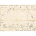
Shows county divisions of colonies and notes on early discoveries and voyages. Relief shown by hachures, some depths shown by soundings. |
|
Produced as one map from two printed sheets, then dissected and mounted on linen as 1 map of 20 folded segments. This reprint originally sold separately folded to 22 x 14 cm, with bound edgings and covers. |
|
Source sheets produced separately and appeared as plates in the several editions of Arrowsmith's London atlas. Copies of the atlas contain differing prints of the plates. |
|
Includes inset maps of Torres Strait, Van Diemens Land, and world map showing Brazil, Africa, Europe, Asia, Australia, New Zealand & Western Pacific. |
| Summary |
Formerly 603C. |
|
Rare. |
| Subjects |
Australia -- Maps -- To 1900.
|
|